
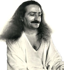
 Meher Baba's Life & Travels


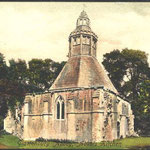
* There are no photos of Meher Baba taken at this location on his visit.
1931
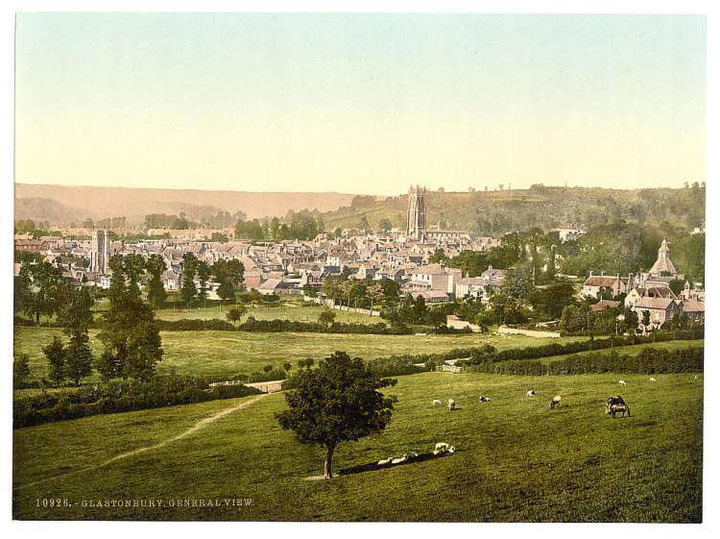
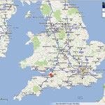
Meher Baba had travelled along the Great West Road ( now the A4 ) on the 13th September 1931, through several towns including Glastonbury, on his way to the retreat at East Challacombe, near Combe Martin and returned back again on the 24th September 1931 to London.
http://www.glastonbury.co.uk/pages/
http://www.glastonburytor.org.uk/


http://asis.com/users/stag/glastonb.html
http://www.philipcoppens.com/glastonbury.html


http://www.glastonburyfestivals.co.uk/
Coordinates: 51.1485°N 2.7140°W

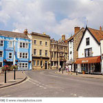
| Glastonbury | |
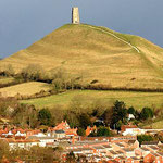
 A view of Glastonbury from the Tor |
|

Glastonbury
|
|
| Population | 8,784 [1] |
|---|---|
| OS grid reference | ST501390 |
| District | Mendip |
| Shire county | Somerset |
| Region | South West |
| Country | England |
| Sovereign state | United Kingdom |
| Post town | Glastonbury |
| Postcode district | BA6 |
| Dialling code | 01458 |
| Police | Avon and Somerset |
| Fire | Devon and Somerset |
| Ambulance | South Western |
| EU Parliament | South West England |
| UK Parliament | Wells |
| List of places: UK • England • Somerset | |
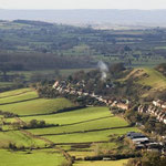
Glastonbury is a small town in Somerset, England, situated at a dry point on the low lying Somerset Levels, 23 miles (37 km) south of Bristol. The town, which is in the Mendip district, had a population of 8,784 in the 2001 census.[1] Glastonbury is less than 1 mile (2 km) across the River Brue from Street, which is now larger than Glastonbury.
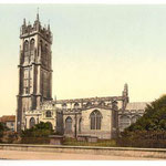
Evidence from timber trackways such as the Sweet Track show that the town has been inhabited since Neolithic times. Glastonbury Lake Village was an Iron Age village, close to the old course of the River Brue and Sharpham Park approximately 2 miles (3.2 km) west of Glastonbury, dates back to the Bronze Age. Centwine was the first Saxon patron of Glastonbury Abbey, which dominated the town for the next 700 years. One of the most important abbeys in England, it was the site of Edmund Ironside's coronation as King of England in 1016. Many of the oldest surviving buildings in the town, including the Tribunal, George Hotel and Pilgrims' Inn and the Somerset Rural Life Museum, which is based in an old tithe barn, are associated with the abbey. The Church of St John the Baptist dates from the 15th century.
The town became a centre for commerce, which led to the construction of the market cross, Glastonbury Canal and the Glastonbury and Street railway station, the largest station on the original Somerset and Dorset Joint Railway. The Brue Valley Living Landscape is a conservation project managed by the Somerset Wildlife Trust and nearby is the Ham Wall National Nature Reserve.
Glastonbury has been described as a New Age community which attracts people with New Age and Neopagan beliefs, and is notable for myths and legends often related to Glastonbury Tor, concerning Joseph of Arimathea, the Holy Grail and King Arthur. In some Arthurian literature Glastonbury is identified with the legendary island of Avalon. Joseph is said to have arrived in Glastonbury and stuck his staff into the ground, when it flowered miraculously into the Glastonbury Thorn. The presence of a landscape zodiac around the town has been suggested but no evidence has been discovered. The Glastonbury Festival, held in the nearby village of Pilton, takes its name from the town.
Contents[hide] |
[edit] History
[edit] Prehistory
During the 7th millennium BC the sea level rose and flooded the valleys and low lying ground surrounding Glastonbury so the Mesolithic people occupied seasonal camps on the higher ground, indicated by scatters of flints.[2] The Neolithic people continued to exploit the reedswamps for their natural resources and started to construct wooden trackways. These included the Sweet Track, west of Glastonbury, which is one of the oldest engineered roads known and was the oldest timber trackway discovered in Northern Europe, until the 2009 discovery of a 6,000 year-old trackway in Belmarsh Prison.[3] Tree-ring dating (dendrochronology) of the timbers has enabled very precise dating of the track, showing it was built in 3807 or 3806 BC.[4] It has been claimed to be the oldest road in the world.[5] The track was discovered in the course of peat digging in 1970, and is named after its discoverer, Ray Sweet.[6] It extended across the marsh between what was then an island at Westhay, and a ridge of high ground at Shapwick, a distance close to 2,000 metres (1.2 mi). The track is one of a network of tracks that once crossed the Somerset Levels. Built in the 39th century BC,[5] during the Neolithic period, the track consisted of crossed poles of ash, oak and lime (Tilia) which were driven into the waterlogged soil to support a walkway that mainly consisted of oak planks laid end-to-end. Since the discovery of the Sweet Track, it has been determined that it was built along the route of an even earlier track, the Post Track, dating from 3838 BC and so 30 years older.[7]

Glastonbury Lake Village was an Iron Age village, close to the old course of the River Brue, on the Somerset Levels near Godney, some 3 miles (5 km) north west of Glastonbury. It covers an area of 400 feet (122 m) north to south by 300 feet (91 m) east to west,[8] and housed around 100 people in five to seven groups of houses, each for an extended family, with sheds and barns, made of hazel and willow covered with reeds, and surrounded either permanently or at certain times by a wooden palisade. The village was built in about 300 BC and occupied into the early Roman period (around 100AD) when it was abandoned, possibly due to a rise in the water level.[9] It was built on a morass on an artificial foundation of timber filled with brushwood, bracken, rubble and clay.[10]
Sharpham Park is a 300-acre (1.2 km2) historic park, 2 miles (3.2 km) west of Glastonbury, which dates back to the Bronze Age.
[edit] Middle Ages
The origin of the name Glastonbury is unclear but when the settlement is first recorded in the 7th and the early 8th century, it was called Glestingaburg.[11] The burg element is Anglo-Saxon and could refer either to a fortified place such as a burh or, more likely, a monastic enclosure, however the Glestinga element is obscure, and may derive from an Old English word or from a Saxon or Celtic personal name.[12][13] It may derive from a person or kindred group named Glast.[13]
William of Malmesbury in his De Antiquitate Glastonie Ecclesie gives the Old Celtic Ineswitrin (or Ynys Witrin) as its earliest name,[13] and asserts that the founder of the town was the eponymous Glast, a descendant of Cunedda.[11]
Centwine (676–685) was the first Saxon patron of Glastonbury Abbey.[14] In 1016 Edmund Ironside was crowned king at Glastonbury.[15] After his death later that year he was buried at the abbey.[16] To the southwest of the town centre is Beckery, which was once a village in its own right but is now part of the suburbs. Around the 7th and 8th centuries it was occupied by a small monastic community associated with a cemetery.[17][18]
Sharpham Park was granted by King Eadwig to the then abbot Æthelwold in 957. In 1191 Sharpham Park was conferred by the soon-to-be King John I to the Abbots of Glastonbury, who remained in possession of the park and house until the dissolution of the monasteries in 1539. From 1539 to 1707 the park was owned by the Duke of Somerset, Sir Edward Seymour, brother of Queen Jane; the Thynne family of Longleat, and the family of Sir Henry Gould. Edward Dyer was born here in 1543. The house is now a private residence and Grade II* listed building.[19] It was the birthplace of Sir Edward Dyer (died 1607) an Elizabethan poet and courtier, the writer Henry Fielding (1707–54), and the cleric William Gould.
In the 1070s St Margaret's Chapel was built on Magdelene Street, originally as a hospital and later as almshouses for the poor. The building dates from 1444.[20] The roof of the hall is thought to have been removed after the Dissolution, and some of the building was demolished in the 1960s. It is Grade II* listed,[21] and a Scheduled ancient monument.[22] In 2010 plans were announced to restore the building.[23]

During the Middle Ages the town largely depended on the abbey but was also a centre for the wool trade until the 18th century. A Saxon-era canal connected the abbey to the River Brue.[12] Richard Whiting, the last Abbot of Glastonbury, was executed with two of his monks on 15 November 1539 during the dissolution of the monasteries.[24]
During the Second Cornish Uprising of 1497 Perkin Warbeck surrendered when he heard that Giles, Lord Daubeney's troops, loyal to Henry VII were camped at Glastonbury.[25]
[edit] Early modern
In 1693 Glastonbury, Connecticut was founded and named after the English town from which some of the settlers had emigrated. It was originally called "Glistening Town" until the mid-19th century when it was changed in line with Glastonbury, England. A representation of the Glastonbury thorn is incorporated onto the town seal.[26]
The Somerset towns charter of incorporation was received in 1705.[12] Growth in the trade and economy largely depended on the drainage of the surrounding moors. The opening of the Glastonbury Canal produced an upturn in trade, and encouraged local building.[12]
The parish was part of the hundred of Glaston Twelve Hides.[27]
[edit] Modern history
By the middle of the 18th century the Glastonbury Canal drainage problems and competition from the new railways caused a decline in trade, and the town's economy became depressed.[12] The canal was closed on 1 July 1854, and the lock and aqueducts on the upper section were dismantled. The railway opened on 17 August 1854.[28] The lower sections of the canal were given to the Commissioners for Sewers,[29] for use as a drainage ditch. The final section was retained to provide a wharf for the railway company, which was used until 1936, when it passed to the Commissioners of Sewers and was filled in.[28] The Central Somerset Railway merged with the Dorset Central Railway to become the Somerset and Dorset Railway.[30] The main line to Glastonbury closed in 1966.[28]
In the Northover district industrial production of sheepskins, woollen slippers and, later, boots and shoes,[31] developed in conjunction with the growth of C&J Clark in Street. Clarks still has its headquarters in Street, but shoes are no longer manufactured there. Instead, in 1993, redundant factory buildings were converted to form Clarks Village, the first purpose-built factory outlet in the United Kingdom.[32]
During the 19th and 20th centuries tourism developed based on the rise of antiquarianism, the association with the abbey and mysticism of the town.[33] This was aided by accessibility via the rail and road network, which has continued to support the town's economy and led to a steady rise in resident population since 1801.[12]
Glastonbury received national media coverage in 1999 when cannabis plants were found in the town's floral displays.[34][35]
[edit] Mythology and legends

Glastonbury is notable for myths and legends concerning Joseph of Arimathea, the Holy Grail and King Arthur. The legend that Joseph of Arimathea retrieved certain holy relics was introduced by the French poet Robert de Boron in his 13th-century version of the grail story, thought to have been a trilogy though only fragments of the later books survive today. The work became the inspiration for the later Vulgate Cycle of Arthurian tales.[36]
De Boron's account relates how Joseph captured Jesus' blood in a cup (the "Holy Grail") which was subsequently brought to Britain. The Vulgate Cycle reworked Boron's original tale. Joseph of Arimathea was no longer the chief character in the Grail origin: Joseph's son, Josephus, took over his role of the Grail keeper.[37] The earliest versions of the grail romance, however, do not call the grail "holy" or mention anything about blood, Joseph or Glastonbury.
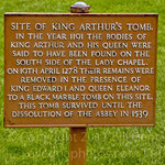
In 1191, monks at the abbey claimed to have found the graves of Arthur and Guinevere to the south of the Lady Chapel of the Abbey Church, which was visited by a number of contemporary historians including Giraldus Cambrensis.[38] The remains were later moved and were lost during the Reformation. Many scholars suspect that this discovery was a pious forgery to substantiate the antiquity of Glastonbury's foundation, and increase its renown.[39]
In some Arthurian literature Glastonbury is identified with the legendary island of Avalon. An early Welsh poem links Arthur to the Tor in an account of a confrontation between Arthur and Melwas, who had kidnapped Queen Guinevere.[40] According to some versions of the Arthurian legend, Lancelot retreated to Glastonbury Abbey in penance following Arthur's death.[41]

Joseph is said to have arrived in Glastonbury by boat over the flooded Somerset Levels. On disembarking he stuck his staff into the ground and it flowered miraculously into the Glastonbury Thorn (or Holy Thorn). This is said to explain a hybrid Crataegus monogyna (hawthorn) tree that only grows within a few miles of Glastonbury, and which flowers twice annually, once in spring and again around Christmas time (depending on the weather). Each year a sprig of thorn is cut, by the local Anglican vicar and the eldest child from St John's School, and sent to the Queen.[42]
The original Holy Thorn was a centre of pilgrimage in the Middle Ages but was chopped down during the English Civil War.[43] A replacement thorn was planted in the 20th century on Wearyall hill (originally in 1951 to mark the Festival of Britain; but the thorn had to be replanted the following year as the first attempt did not take).[44] Many other examples of the thorn grow throughout Glastonbury including those in the grounds of Glastonbury Abbey, St Johns Church and Chalice Well.
Today Glastonbury Abbey presents itself as "traditionally the oldest above-ground Christian church in the world," which according to the legend was built at Joseph's behest to house the Holy Grail, 65 or so years after the death of Jesus.[45] The legend also says that as a child, Jesus had visited Glastonbury along with Joseph. The legend probably was encouraged during the medieval period when religious relics and pilgrimages were profitable business for abbeys. William Blake mentioned the legend in a poem that became a popular hymn, "Jerusalem" (see And did those feet in ancient time).[46]
[edit] Glastonbury zodiac
In 1934 artist Katherine Maltwood suggested a landscape zodiac, a map of the stars on a gigantic scale, formed by features in the landscape such as roads, streams and field boundaries, could be found situated around Glastonbury. [47] She held that the "temple" was created by Sumerians about 2700 BC. The idea of a prehistoric landscape zodiac fell into disrepute when two independent studies examined the Glastonbury Zodiac, one by Ian Burrow in 1975 [48] and the other by Tom Williamson and Liz Bellamy in 1983. [49] These both used standard methods of landscape historical research. Both studies concluded that the evidence contradicted the idea of an ancient zodiac. The eye of Capricorn identified by Maltwood was a haystack. The western wing of the Aquarius phoenix was a road laid in 1782 to run around Glastonbury, and older maps dating back to the 1620s show the road had no predecessors. The Cancer boat (not a crab as in conventional western astrology) consists of a network of 18th-century drainage ditches and paths. There are some Neolithic paths preserved in the peat of the bog formerly comprising most of the area, but none of the known paths match the lines of the zodiac features. There is no support for this theory, or for the existence of the "temple" in any form, from conventional archaeologists.[50] Glastonbury is also said to be the centre of several ley lines.[51]
[edit] Governance and public services

The town council is made up of 16 members,[52] and is based at the Town Hall, Magdalene Street. The town hall was built in 1818 and has a two-storey late Georgian ashlar front. It is a Grade II* listed building.[53]
Glastonbury is in the local government district of Mendip, which is part of the county of Somerset. It was previously administered by Glastonbury Municipal Borough.[54] The Mendip district council is responsible for local planning and building control, local roads, council housing, environmental health, markets and fairs, refuse collection and recycling, cemeteries and crematoria, leisure services, parks, and tourism. Somerset County Council is responsible for running the largest and most expensive local services such as education, social services, the library, road maintenance, trading standards, waste disposal and strategic planning.
The town's retained fire station is operated by Devon and Somerset Fire and Rescue Service,[55] whilst police and ambulance services are provided by Avon and Somerset Constabulary and the South Western Ambulance Service. There are two doctors' surgeries in Glastonbury,[56] and a National Health Service community hospital operated by Somerset Primary Care Trust which opened in 2005.[57]
Glastonbury falls within the Wells constituency, represented in the House of Commons of the Parliament of the United Kingdom. It elects one Member of Parliament (MP) by the first past the post system of election. The Member of Parliament is Tessa Munt of the Liberal Democrats.[58] It is within the South West England (European Parliament constituency), which elects six MEPs using the d'Hondt method of party-list proportional representation.
Glastonbury is twinned with the Greek island of Patmos,[59] and Lalibela, Ethiopia.[60]
[edit] Geography

The walk up the Tor to the distinctive tower at the summit (the partially restored remains of an old church) is rewarded by vistas of the mid-Somerset area, including the Levels which are drained marshland. From there, on a dry point, 158 metres (518 ft) above sea level,[61] it is easy to appreciate how Glastonbury was once an island and, in the winter, the surrounding moors are often flooded, giving that appearance once more. It is an agricultural region typically with open fields of permanent grass, surrounded by ditches with willow trees. Access to the moors and Levels is by "droves", i.e., green lanes. The Levels and inland moors can be 6 metres (20 ft) below peak tides and have large areas of peat. The low lying areas are underlain by much older Triassic age formations of Upper Lias sand that protrude to form what would once have been islands and include Glastonbury Tor.[62][63] The lowland landscape was formed only during the last 10,000 years, following the end of the last ice age.[64]
The low lying damp ground can produce a visual effect known as a Fata Morgana. This optical phenomenon occurs because rays of light are strongly bent when they pass through air layers of different temperatures in a steep thermal inversion where an atmospheric duct has formed.[65] The Italian name Fata Morgana is derived from the name of Morgan le Fay, who was alternatively known as Morgane, Morgain, Morgana and other variants. Morgan le Fay was described as a powerful sorceress and antagonist of King Arthur and Queen Guinevere in the Arthurian legend.
Glastonbury is less than 1 mile (2 km) across the River Brue from the village of Street. At the time of King Arthur the Brue formed a lake just south of the hilly ground on which Glastonbury stands. This lake is one of the locations suggested by Arthurian legend as the home of the Lady of the Lake. Pomparles Bridge stood at the western end of this lake, guarding Glastonbury from the south, and it is suggested that it was here that Sir Bedivere threw Excalibur into the waters after King Arthur fell at the Battle of Camlann.[66] The old bridge was replaced by a reinforced concrete arch bridge in 1911.[67]
Until the 13th century, the direct route to the sea at Highbridge was prevented by gravel banks and peat near Westhay.[68] The course of the river partially encircled Glastonbury from the south, around the western side (through Beckery), and then north through the Panborough-Bleadney gap in the Wedmore-Wookey Hills, to join the River Axe just north of Bleadney. This route made it difficult for the officials of Glastonbury Abbey to transport produce from their outlying estates to the abbey, and when the valley of the River Axe was in flood it backed up to flood Glastonbury itself. Some time between 1230 and 1250 a new channel was constructed westwards into Meare Pool north of Meare, and further westwards to Mark Moor. The Brue Valley Living Landscape is a conservation project based on the Somerset Levels and Moors and managed by the Somerset Wildlife Trust.[69] The project commenced in January 2009 and aims to restore, recreate and reconnect habitat, ensuring that wildlife is enhanced and capable of sustaining itself in the face of climate change, while guaranteeing farmers and other landowners can continue to use their land profitably.[69] It is one of an increasing number of landscape scale conservation projects in the UK.[70][71]

The Ham Wall National Nature Reserve, 4 kilometres (2.5 mi) west of Glastonbury, is managed by the Royal Society for the Protection of Birds.[72][73] This new wetland habitat has been established from out peat diggings and now consists of areas of reedbed, wet scrub, open water and peripheral grassland and woodland. Bird species living on the site include the Bearded Tit and the Bittern.[74]
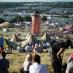
The Whitelake River rises between two low limestone ridges to the north of Glastonbury, part of the southern edge of the Mendip Hills. The confluence of the two small streams that make the Whitelake River is on Worthy Farm, the site of the Glastonbury Festival, between the small villages of Pilton and Pylle.
[edit] Climate
Along with the rest of South West England, Glastonbury has a temperate climate which is generally wetter and milder than the rest of the country.[75] The annual mean temperature is approximately 10 °C (50.0 °F). Seasonal temperature variation is less extreme than most of the United Kingdom because of the adjacent sea temperatures. The summer months of July and August are the warmest with mean daily maxima of approximately 21 °C (69.8 °F). In winter mean minimum temperatures of 1 °C (33.8 °F) or 2 °C (35.6 °F) are common.[75] In the summer the Azores high pressure affects the south-west of England, however convective cloud sometimes forms inland, reducing the number of hours of sunshine. Annual sunshine rates are slightly less than the regional average of 1,600 hours.[75] In December 1998 there were 20 days without sun recorded at Yeovilton. Most the rainfall in the south-west is caused by Atlantic depressions or by convection. Most of the rainfall in autumn and winter is caused by the Atlantic depressions, which is when they are most active. In summer, a large proportion of the rainfall is caused by sun heating the ground leading to convection and to showers and thunderstorms. Average rainfall is around 700 mm (28 in). About 8–15 days of snowfall is typical. November to March have the highest mean wind speeds, and June to August have the lightest winds. The predominant wind direction is from the south-west.[75]
[edit] Economy

Glastonbury is a centre for religious tourism and pilgrimage. As with many towns of similar size, the centre is not as thriving as it once was but Glastonbury supports a large number of alternative shops.
The outskirts of the town contain a DIY shop a former sheepskin and slipper factory site, once owned by Morlands, which is slowly being redeveloped. The 31-acre (13 ha) site of the old Morlands factory was scheduled for demolition and redevelopment into a new light industrial park,[76][77] although there have been some protests that the buildings should be reused rather than being demolished. As part of the redevelopment of the site a project has been established by the Glastonbury Community Development Trust to provide support for local unemployed people applying for employment, starting in self-employment and accessing work-related training.[78]
[edit] Landmarks
The Tribunal was a medieval merchant's house, used as the Abbey courthouse and, during the Monmouth Rebellion trials, by Judge Jeffreys.[79] It now serves as a museum containing possessions and works of art from the Glastonbury Lake Village which were preserved in almost perfect condition in the peat after the village was abandoned. The museum is run by the Glastonbury Antiquarian Society.[80] The building also houses the tourist information centre.[81]

The octagonal Market Cross was built in 1846 by Benjamin Ferrey.[82]
The George Hotel and Pilgrims' Inn was built in the late 15th century to accommodate visitors to Glastonbury Abbey, which is open to visitors. It has been designated as a Grade I listed building.[83] The front of the 3-storey building is divided into 3 tiers of panels with traceried heads. Above these are 3 carved panels with arms of the Abbey and Edward IV.[83]
The Somerset Rural Life Museum is a museum of the social and agricultural history of Somerset, housed in buildings surrounding a 14th-century barn once belonging to Glastonbury Abbey. It was used for the storage of arable produce, particularly wheat and rye, from the abbey's home farm of approximately 524 acres (2.12 km2). Threshing and winnowing would also have been carried out in the barn, which was built from local "shelly" limestone with thick timbers supporting the stone tiling of the roof. It has been designated by English Heritage as a grade I listed building, and is a Scheduled Ancient Monument.[84]

The Chalice Well is a holy well at the foot of the Tor, covered by a wooden well-cover with wrought-iron decoration made in 1919. The natural spring has been in almost constant use for at least two thousand years. Water issues from the spring at a rate of 25,000 imperial gallons (110,000 l; 30,000 US gal) per day and has never failed, even during drought. Iron oxide deposits give the water a reddish hue, as dissolved ferrous oxide becomes oxygenated at the surface and is precipitated, providing chalybeate waters. As with the hot springs in nearby Bath, the water is believed to possess healing qualities. The well is about 9 feet (2.7 m) deep, with two underground chambers at its bottom.[85] It is often portrayed as a symbol of the female aspect of deity, with the male symbolised by Glastonbury Tor. As such, it is a popular destination for pilgrims in search of the divine feminine, including modern Pagans. The well is however popular with all faiths and in 2001 became a World Peace Garden.[86]
[edit] Transport

The Glastonbury Canal ran just over 14 miles (23 km) through two locks from Glastonbury to Highbridge where it entered the Bristol Channel in the early 19th century,[87] but it became uneconomic with the arrival of the railway in the 1840s.[88]
Glastonbury and Street railway station was the biggest station on the original Somerset and Dorset Joint Railway main line from Highbridge to Evercreech Junction until closed in 1966 under the Beeching axe. Opened in 1854 as Glastonbury, and renamed in 1886, it had three platforms, two for Evercreech to Highbridge services and one for the branch service to Wells. The station had a large goods yard controlled from a signal box.[89] The site is now a timber yard for a local company. Replica level crossing gates have been placed at the entrance.[90]
The main road in the town is the A39 which passes through Glastonbury from Wells connecting the town with Street and the M5 motorway. The other roads around the town are small and run across the levels generally following the drainage ditches. Local bus services are provided by Badgerline, Nippy Bus, National Express and local community groups.[91]
[edit] Education
There are several infant and primary schools in Glastonbury and the surrounding villages. Secondary education is provided by St Dunstan's Community School. As of 2009, the school had 639 students between the ages of 11 and 16 years.[92] It is named after St. Dunstan, an abbot of Glastonbury Abbey, who went on to become the Archbishop of Canterbury in 960 AD. The school was built in 1958 with major building work, at a cost of £1.2 million, in 1998, adding the science block and the sports hall. It was designated as a specialist Arts College in 2004, and the £800,000 spent at this time paid for the Performing Arts studio and facilities to support students with special educational needs.[93]
Strode College in Street provides academic and vocational courses for those aged 16–18 and adult education. A tertiary institution and further education college, most of the courses it offers are A-levels or Business and Technology Education Councils (BTECs). The college also provides some university-level courses,[94] and is part of The University of Plymouth Colleges network.
[edit] Religious sites

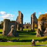
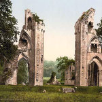
Glastonbury may have been a site of religious importance in pre-Christian times.[95] The abbey was founded by Britons, and dates to at least the early 7th century, although later medieval Christian legend claimed that the abbey was founded by Joseph of Arimathea in the 1st century. This fanciful legend is intimately tied to Robert de Boron's version of the Holy Grail story and to Glastonbury's connection to King Arthur, which dates at least to the early 12th century.[96] Glastonbury fell into Saxon hands after the Battle of Peonnum in 658. King Ine of Wessex enriched the endowment of the community of monks already established at Glastonbury. He is said to have directed that a stone church be built in 712. The Abbey Church was enlarged in the 10th century by the Abbot of Glastonbury, Saint Dunstan, the central figure in the 10th-century revival of English monastic life. He instituted the Benedictine Rule at Glastonbury and built new cloisters. Dunstan became Archbishop of Canterbury in 960. In 1184, a great fire at Glastonbury destroyed the monastic buildings. Reconstruction began almost immediately and the Lady Chapel, which includes the well, was consecrated in 1186.[97]

The abbey had a violent end during the Dissolution and the buildings were progressively destroyed as their stones were removed for use in local building work. The remains of the Abbot's Kitchen (a grade I listed building.[98]) and the Lady Chapel are particularly well-preserved set in 36 acres (150,000 m2) of parkland. It is approached by the Abbey Gatehouse which was built in the mid-14th century and completely restored in 1810.[99]
The Church of St Benedict was rebuilt by Abbot Richard Beere in about 1520.[100]
The Church of St John the Baptist dates from the 15th century and has been designated as a Grade I listed building.[101] The church is laid out in a cruciform plan with an aisled nave and a clerestorey of seven bays. The west tower has elaborate buttressing, panelling and battlements. The interior of the church includes four 15th-century tomb-chests, some 15th-century stained glass in the chancel, medieval vestments, and a domestic cupboard of about 1500 which was once at Witham Charterhouse.[102]
The United Reformed Church on the High Street was built in 1814 and altered in 1898. It stands on the site of the Ship Inn where meetings were held during the 18th century. It is Grade II listed.[103]
The Glastonbury Goddess Temple was founded in 2002 and registered as a place of worship the following year. It is self-described as the first temple of its kind to exist in Europe in over a thousand years.[104][105]
[edit] Sports

The local football side is Glastonbury Town F.C.. They joined the Western Football League Division Two as Glastonbury in 1919 and won the Western Football League title three times in their history.[106] They changed their name to Glastonbury Town in 2003. For the 2010–11 season, they are members of the Somerset County Football League Premier Division.[107]
Glastonbury Cricket Club competes in the West of England Premier League, one of the ECB Premier Leagues, the highest level of recreational cricket in England and Wales.[108] The club plays at the Tor Leisure Ground, which used to stage Somerset County Cricket Club first-class fixtures.
[edit] Culture
Glastonbury has been described as a New Age community where communities have grown up to include people with New Age beliefs.[109][110]
In a 1904 novel by Charles Whistler entitled A Prince of Cornwall Glastonbury in the days of Ine of Wessex is portrayed. It is also a setting in the Warlord Chronicles a trilogy of books about Arthurian Britain written by Bernard Cornwell.[111] Modern fiction has also used Glastonbury as a setting including The Age of Misrule series of books by Mark Chadbourn in which the Watchmen appear, a group selected from Anglican priests in and around Glastonbury to safeguard knowledge of a gate to the Otherworld on top of Glastonbury Tor.[112]
The first Glastonbury Festivals were a series of cultural events held in summer, from 1914 to 1926. The festivals were founded by English socialist composer Rutland Boughton and his librettist Lawrence Buckley.[113] Apart from the founding of a national theatre, they envisaged a summer school and music festival based on utopian principles.[114] With strong Arthurian connections and historic and prehistoric associations, Glastonbury was chosen to host the festivals.
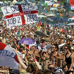
The more recent Glastonbury Festival of Performing Arts, founded in 1970, is now the largest open-air music and performing arts festival in the world. Although it is named for Glastonbury, it is held at Worthy Farm between the small villages of Pilton and Pylle, 6 miles (9.7 km) east of the town of Glastonbury.[115] The festival is best known for its contemporary music, but also features dance, comedy, theatre, circus, cabaret and many other arts. For 2005, the enclosed area of the festival was over 900 acres (3.6 km2), had over 385 live performances and was attended by around 150,000 people. In 2007, over 700 acts played on over 80 stages[116] and the capacity expanded by 20,000 to 177,000.[117] The festival has spawned a range of other work including the 1972 film Glastonbury Fayre[118] and album, 1996 film Glastonbury the Movie[119] and the 2005 DVD Glastonbury Anthems.[120]
The Children's World charity grew out of the festival and is based in the town. It is known internationally (as Children's World International). It was set up by Arabella Churchill in 1981 to provide drama participation and creative play and to work creatively in educational settings, providing social and emotional benefits for all children, particularly those with special needs.[121] Children's World International is the sister charity of Children's World and was started in 1999 to work with children in the Balkans, in conjunction with Balkan Sunflowers and Save the Children. They also run the Glastonbury Children's Festival each August.[122]
Glastonbury is one of the venues for the annual West Country Carnival.[123]
[edit] Notable people
Glastonbury has been the birthplace or home to many notable people. Peter King, 1st Baron King was the recorder of Glastonbury in 1705.[124] Thomas Bramwell Welch the discoverer of the pasteurisation process to prevent the fermentation of grape juice was born in Glastonbury in 1825.[125] The judge John Creighton represented Lunenburg County in the Nova Scotia House of Assembly from 1770 to 1775.[126] The fossil collector Thomas Hawkins lived in the town during the 19th century.[127]
The religious connections and mythology of the town have also attracted several authors. The occultist and writer Dion Fortune (Violet Mary Firth) lived and is buried in Glastonbury.[128] Her old house is now home to the writer and historian Geoffrey Ashe, who is known for his works on local legends. Frederick Bligh Bond, archaeologist and writer.[129] Eckhart Tolle, a German-born writer, public speaker, and spiritual teacher lived in Glastonbury during the 1980s.[130] Eileen Caddy was at a sanctuary in Glastonbury when she first claimed to have heard the "voice of God" while meditating. Her subsequent instructions from the "voice" directed her to take on Sheena Govan has her spiritual teacher,[131][132][133][134] and became a spiritual teacher and new age author, best known as one of the founders of the Findhorn Foundation community. Sally Morningstar, a Wiccan High Priestess and the author of at least twenty-six books on magic, astrology, Ayurveda, Wicca, divination and spirituality teaches Hedge Witchcraft and Natural Magic in Glastonbury,[135] and lives in Somerset.
Popular entertainment and literature is also represented amongst the population. Rutland Boughton moved from Birmingham to Glastonbury in 1911 and established the country's first national annual summer school of music.[136] Gary Stringer, lead singer of Reef, was a local along with other members of the band,[137] as are the band Flipron.[138] The juggler Haggis McLeod and his late wife, Arabella Churchill, one of the founders of the Glastonbury Festival, lived in the town.[139] The author and dramatist Nell Leyshon and she has set much of her work in the local area.[140] Sarah Fielding, the 18th-century author and sister of the novelist Henry Fielding, lived in the town.[141] Michael Aldridge, a character actor who appeared as Seymour in the television series Last of the Summer Wine, was born in Glastonbury.[142] The conductor Charles Hazlewood lives locally and hosts the "Play the Field" music festival on his farm nearby.[143] Bill Bunbury moved on from Glastonbury to become a writer, radio broadcaster, and producer for the Australian Broadcasting Corporation.[144]
Athletes and sports players have also been resident. Cricketers born in the town include Cyril Baily in 1880,[145] George Burrough in 1907,[146] and Eustace Bisgood in 1878.[147] The footballer Peter Spiring was born in Glastonbury in 1950.[148]