
 Meher Baba's Life & Travels


AZORES ISLANDS
( Portugal )


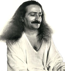
* There are no photos of Meher Baba taken in the Azores Islands on his visit.
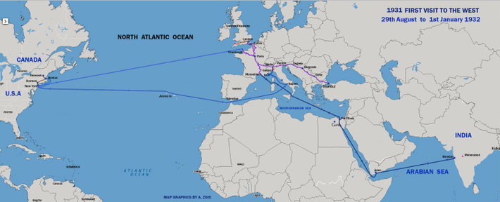
1931
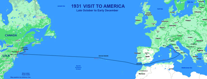
Meher Baba's first visit to America
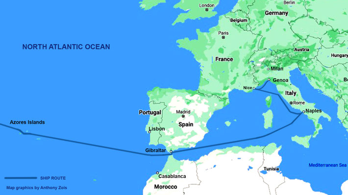
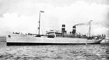
Meher Baba sailed from Genoa, Italy on the SS ROMA on 27th October 1931.
The ship put into Nice, France then to Naples, Italy ( 28th ) then called into Gibraltar [Br.] ( 30th ).
The ship then sailed to Azores Islands (Portugal) on the 1st November. The ship then continued to the U.S.A.
The ship arrived in New York on the 6th Nov. Baba and his men mandali went immediately to Harmon-on-Hudson near Croton.
Azores Islands

| Azores (Açores) | |||
| Autonomous Region (Região Autónoma) | |||

Mount Pico and the green landscape, emblematic of the archipelago of the Azores
|
|||
|
|||
| Official name: Região Autónoma dos Açores | |||
| Name origin: açor, Portuguese for species of rapier bird, erroneously identified as goshawks; also derivation from the word for blue | |||
|
Motto: Antes morrer livres que em paz sujeitos (English: Rather die as free men than be enslaved in peace) |
|||
| Country |
|
||
|---|---|---|---|
| Autonomous Region |
|
||
| Region | Atlantic Ocean | ||
| Subregion | Mid-Atlantic Ridge | ||
| Position | Azores Platform | ||
| Islands | Corvo, Faial, Flores, Graciosa, Pico, São Jorge, São Miguel, Santa Maria, Terceira | ||
| Municipalities | Angra do Heroísmo, Horta, Lagoa, Lajes das Flores, Lajes do Pico, Madalena, Nordeste, Povoação, Praia da Vitória, Ponta Delgada, Ribeira Grande, Santa Cruz da Graciosa, Santa Cruz das Flores, São Roque, Vila do Corvo, Vila do Porto, Vila Franca do Campo | ||
| Capitals | Angra do Heroísmo[1], Horta[2], Ponta Delgada[3] | ||
| Largest city | Ponta Delgada | ||
| - center | São José | ||
| - elevation | 22 m (72 ft) | ||
| - coordinates | 37°44′28″N 25°40′32″W | ||
| Highest point | Mount Pico | ||
| - elevation | 2,351 m (7,713 ft) | ||
| - coordinates | 38°28′19″N 28°51′50″W | ||
| Lowest point | Sea level | ||
| - location | Atlantic Ocean | ||
| - elevation | 0 m (0 ft) | ||
| Area | 2,333 km2 (901 sq mi) | ||
| Population | 245,746 (2012) Census 2011 | ||
| Density | 105.87 / km2 (274 / sq mi) | ||
| Settlement | 15 August 1432 | ||
| - Administrative autonomy | c. 1895 | ||
| - Political autonomy | 4 September 1976 | ||
| Discovery | c. 1427 | ||
| - Santa Maria | c. 1427 | ||
| - São Miguel | c. 1428 | ||
| Management | |||
| - location | Assembleia Regional, Rua Marcelino Lima, Horta, Faial | ||
| - elevation | 46 m (151 ft) | ||
| - coordinates | 38°32′6″N 28°37′51″W | ||
| Government | |||
| - location | Palácio de Santana, Rua José Jácome Correia, Ponta Delgada, São Miguel | ||
| - elevation | 60 m (197 ft) | ||
| - coordinates | 37°44′52″N 25°40′19″W | ||
| President (Government) | Vasco Cordeiro (PS) | ||
| - President (Assembleia) | Ana Luís (PS) | ||
| Timezone | Azores (UTC-1) | ||
| - summer (DST) | Azores EST (UTC0) | ||
| ISO 3166-2 code | PT-20 | ||
| Postal code | 9XXX-XXX | ||
| Area code | (+351) 29X XX XX XX[4] | ||
| ccTLD | .pt | ||
| Demonym | Azorean | ||
| Patron Saint | Espírito Santo | ||
| Holiday | 51st day (Monday) following Easter (Dia da Região Autónoma dos Açores) | ||
| Anthem |
A Portuguesa (national) Hino dos Açores (regional) |
||
| Currency | Euro (€)[5] | ||
| Date format | dd-mm-yyyy | ||
| Drive | right-side | ||

Location of the Azores relative to Portugal (green) and the rest of the European
Union (dark blue)
|
|||
|
Distribution of the islands of the archipelago
|
|||
| Wikimedia Commons: Azores | |||
| Statistics: Instituto Nacional de Estatística[6] | |||
| Website: www.azores.gov.pt | |||
| Geographic detail from CAOP (2010)[7] produced by Instituto Geográfico Português (IGP) | |||


The Azores (UK /əˈzɔrz/ ə-ZORZ, US /ˈeɪzɔrz/ AY-zorz; Portuguese: Açores, [ɐˈsoɾɨʃ]), officially the Autonomous Region of the Azores (Região Autónoma dos Açores) is one of the two autonomous regions of Portugal, composed of nine volcanic islands situated in the North Atlantic Ocean, and is located about 1,360 km (850 mi) west of continental Portugal, about 880 km (550 mi) northwest of Madeira, and about 1,925 km (1,196 mi) southeast of Newfoundland. Its main industries are agriculture, dairy farming (for cheese and butter products primarily), livestock ranching, fishing, and tourism, which is becoming the major service activity in the region. In addition to this, the government of the Azores employs a large percentage of the population directly or indirectly in many aspects of the service and tertiary sectors.
There are nine major Azorean islands and an islet cluster, in three main groups. These are Flores and Corvo, to the west; Graciosa, Terceira, São Jorge, Pico, and Faial in the centre; and São Miguel, Santa Maria, and the Formigas Reef to the east. They extend for more than 600 km (370 mi) and lie in a northwest-southeast direction.
The vast extent of the islands defines an immense exclusive economic zone of 1,100,000 km2 (420,000 sq mi). The westernmost point of this area is 3,380 km (2,100 mi) from the North American continent.[citation needed][dubious ] All the islands have volcanic origins, although some, such as Santa Maria, have had no recorded activity since the islands were settled. Mount Pico, on the island of Pico, is the highest point in Portugal, at 2,351 m (7,713 ft). The Azores are actually some of the tallest mountains on the planet, measured from their base at the bottom of the ocean to their peaks, which thrust high above the surface of the Atlantic.
Because these once-uninhabited and remote islands were settled sporadically over a span of two centuries, their culture, dialect, cuisine, and traditions vary considerably.
Contents
History
A small number of alleged Hypogea, earthen structures carved into rocks that were used for burials, have been identified on the islands of Corvo, Santa Maria and Terceira by Portuguese archaeologist Nuno Ribeiro and speculations were published that they might date back 2000 years, alluding to a human presence on the island before the Portuguese.[8] However, these kinds of structures have always been used in the Azores to store cereals, and suggestions by Ribeiro that they might be burial sites are unconfirmed. Detailed examination and dating to authenticate the validity of these speculations is lacking.[9] So far, it is unclear whether these structures are natural or man-made and whether they predate the 15th-century Portuguese colonization of the Azores. Solid confirmation of a pre-Portuguese human presence in the archipelago has not yet been published.
Discovery

The islands were known in the fourteenth century and parts of them can be seen, for example, in the Atlas Catalan. In 1427, one of the captains sailing for Henry the Navigator, possibly Gonçalo Velho, rediscovered the Azores, but this is not certain. In Thomas Ashe's 1813 work"A History of the Azores",[10] the author identified a Fleming, Joshua Vander Berg of Bruges, who made landfall in the archipelago during a storm on his way to Lisbon.[10] Ashe stated that the Portuguese explored the area and claimed it for Portugal shortly after.[10] Other stories note the discovery of the first islands (São Miguel Island, Santa Maria Island and Terceira Island) were made by sailors in the service of Henry the Navigator, although there are few written documents to support the claims.
Although it is commonly said that the archipelago received its name from the goshawk (Açor in Portuguese), a common bird at the time of discovery, it is unlikely that the bird nested or hunted in the islands. Some people, however, insist that the name is derived from birds, pointing to a local subspecies of the buzzard (Buteo buteo) as the animal the first explorers erroneously identified as goshawks.
Settlement
|
|
This section includes a list of references, related reading or external links, but the sources of this section remain unclear because it lacks inline citations. (April 2013) |

At some point, following the discovery of Santa Maria, sheep were let loose on the island before settlement actually took place. This was done to supply the future settlers with food because there were no large animals on the island. Settlement did not take place right away, however. There was not much interest among the Portuguese people in an isolated archipelago hundreds of miles from civilization. However, Cabral patiently gathered resources and settlers for the next three years (1433–1436) and sailed to establish colonies on Santa Maria first and then São Miguel next.
Bush had to be cleared and rocks removed for the planting of crops; grain, grape vines, sugar cane, and other plants suitable for settler use and of commercial value, were planted. Domesticated animals such as chickens, rabbits, cattle, sheep, goats, and hogs were brought. Houses were built and villages established.
The archipelago was settled over the centuries largely from mainland Portugal. Portuguese settlers came from the provinces of Algarve, Minho, Alentejo and Ribatejo as well as Madeira. São Miguel was first settled in 1444, the settlers – mainly from the Estremadura, Alto Alentejo and Algarve areas of Portugal, under the command of Gonçalo Velho Cabral – landing at the site of modern-day Povoação. In 1522 Vila Franca do Campo, then the capital of the island, was devastated by a landslide caused by an earthquake which killed about 5,000 people, and the capital was moved to Ponta Delgada. The town of Vila Franca do Campo was rebuilt on the original site and today is a thriving fishing and yachting port. Ponta Delgada received its city status in 1546. Since the first settlement, the pioneers applied themselves to the area of agriculture. By the 15th century Graciosa exported wheat, barley, wine and brandy. The goods were sent to Terceira largely because of the proximity of the island.
During the 18th and 19th century, Graciosa was host to many prominent figures, including Chateaubriand, the French writer who passed through upon his escape to America during the French revolution; Almeida Garrett, the Portuguese poet who visited an uncle and wrote some poetry while there; and Prince Albert of Monaco, the 19th century oceanographer who led several expeditions in the waters of the Azores. He arrived on his yacht "Hirondelle", and visited the "furna da caldeira", the noted hot springs grotto. Author Mark Twain published in 1869, "The Innocents Abroad" a travel book, where he described his time in the Azores.
The first reference to the island of São Jorge was made in 1439 but the actual date of discovery is unknown. In 1443 the island was already inhabited but active settlement only began with the arrival of the noble Flemish native Wilhelm Van der Haegen. Arriving at Topo, where he lived and died, he became known as Guilherme da Silveira to the islanders. João Vaz Corte-Real received the captaincy of the island in 1483. Velas became a town before the end of the 15th century. By 1490, there were 2,000 Flemings living in the islands of Terceira, Pico, Faial, São Jorge and Flores. Because there was such a large Flemish settlement, the Azores became known as the Flemish Islands or the Isles of Flanders. Prince Henry the Navigator was responsible for this settlement. His sister, Isabel, was married to Duke Philip of Burgundy of which Flanders was a part. There was a revolt against Philip's rule and disease and hunger became rampant. Isabel appealed to Henry to allow some of the unruly Flemings to settle in the Azores. He granted this and supplied them with the necessary transportation and goods.
The settlement of the then-unoccupied islands started in 1439 with people mainly from the continental provinces of Algarve and Alentejo. In 1583, Philip II of Spain, as king of Portugal, sent his fleet to clear the Azores of a combined multinational force of adventurers, mercenaries, volunteers and soldiers who were attempting to establish the Azores as a staging post for a rival pretender to the Portuguese throne. Following the success of his fleet at the Battle of Ponta Delgada, the captured enemies were hanged from yardarms, as they were considered pirates by Philip II. This was added to the "Black Legend" by his enemies.[citation needed] An English expedition against the Azores in 1597, the Islands Voyage, also failed. Spain held the Azores in what is called The Babylonian captivity of 1580–1642. Into the late 16th century, the Azores as well as Madeira began to face problems of overpopulation. Spawning from that particular economic problem, some of the people began to emigrate to Brazil.[11]
Iberian Union
Following the death of Henry, the Cardinal-King of Portugal the nation fell into a dynastic crisis with various pretenders to the Crown of Portugal.[12] Following his proclamation in Santarém, António, Prior of Crato was acclaimed in the Azores in 1580 (through his envoy António da Costa), but was explused from the continent following the Battle of Alcântara.[12] Yet, through the administration of Cipriano de Figueiredo, governor of Terceira (who continued to govern Terceira in the name of ill-fated, former-king Sebastian of Portugal), the Azoreans resisted attempts to conquer the islands (including specifically at the Battle of Salga).[13] It was Figueiredo and Violante do Canto who helped organize a resistance on Terceira that influenced some of the response of the other islands, even as internal politics and support for Philip's faction increased on the other islands (including specifically on São Miguel, where the Gonçalvez da Câmara family supported the Spanish pretender).[13]
The Azores were the last part of the Portuguese Empire to resist Philip's reign over Portugal (Macau resisted any official recognition) and were returned to Portuguese control with the end of the Iberian Union in 1640, not by the professional military, who were used in the Restoration War in the mainland, but by local people attacking a fortified Castilian garrison.
Liberal Wars
|
|
This section includes a list of references, related reading or external links, but the sources of this section remain unclear because it lacks inline citations. (April 2013) |
The Portuguese Civil War (1828–1834) had strong repercussions in the Azores. In 1829, in Praia da Vitória, the Liberals won over the absolutists, making Terceira Island the main headquarters of the new Portuguese regime and also where the Council of Regency (Conselho de Regência) of Maria II of Portugal was established.
Beginning in 1868, Portugal issued its stamps overprinted with "AÇORES" for use in the islands. Between 1892 and 1906, it also issued separate stamps for the three administrative districts of the time.
From 1836 to 1976, the archipelago was divided into three districts, equivalent (except in area) to those in the Portuguese mainland. The division was arbitrary, and did not follow the natural island groups, rather reflecting the location of each district capital on the three main cities (none of which were on the western group).
- Angra do Heroísmo consisted of Terceira, São Jorge, and Graciosa, with the capital at Angra do Heroísmo on Terceira.
- Horta consisted of Pico, Faial, Flores, and Corvo, with the capital at Horta on Faial.
- Ponta Delgada consisted of São Miguel and Santa Maria, with the capital at Ponta Delgada on São Miguel.
20th century
In 1931 the Azores (together with Madeira and Portuguese Guinea) revolted against the Ditadura Nacional and were held briefly by military rebels.[14]
In 1943, during World War II, the Portuguese ruler António de Oliveira Salazar leased air and naval bases in the Azores to the British Empire.[15] The occupation of these facilities in October 1943 was codenamed Operation Alacrity by the British.[16]
This was a key turning point in the Battle of the Atlantic, enabling the Royal Air Force, the U.S. Army Air Forces, and the U.S. Navy to provide aerial coverage in the Mid-Atlantic gap. This helped them to protect convoys and to hunt hostile Kriegsmarine U-boats.
In 1944, the American armed forces constructed a small and short-lived air base on the island of Santa Maria. In 1945, a new base was constructed on the island of Terceira, and it is named Lajes Field. This air base is in an area called Lajes, a broad, flat sea terrace that had been a large farm. Lajes Field is a plateau rising out of the sea on the northeast corner of the island. This air base is a joint American and Portuguese venture. Lajes Field continues to support the American and Portuguese Armed Forces. During the Cold War, U.S. Navy P-3 Orion antisubmarine warfare squadrons patrolled the North Atlantic Ocean for Soviet Navy submarines and surface warships. Since its opening, Lajes Field has been used for refuelling American cargo planes bound for Europe, Africa, and the Middle East. The U.S. Navy keeps a small squadron of its ships at the harbor of Praia da Vitória, three kilometers southeast of Lajes Field.
The airfield also has a small commercial terminal handling scheduled and chartered passenger flights from the other islands in the Azores, Europe, Africa, and North America.
In 1976, the Azores became the Autonomous Region of the Azores (Região Autónoma dos Açores), one of the autonomous regions of Portugal, and the subdistricts of the Azores were eliminated.
Geography
Physical geography
| Island | Area | |
|---|---|---|
| km2 | sq mi | |
| São Miguel | 759 | 293 |
| Pico | 446 | 172 |
| Terceira | 403 | 156 |
| São Jorge | 246 | 95 |
| Faial | 173 | 67 |
| Flores | 143 | 55 |
| Santa Maria | 97 | 37 |
| Graciosa | 62 | 24 |
| Corvo | 17 | 7 |
The archipelago of the Azores is located in the middle of the northern hemisphere of the Atlantic Ocean and extends along a west-northwest to east-southeast orientation (between 36.5°–40° North latitudes and 24.5°–31.5° West longitudes) in an area approximately 600 kilometres (373 miles) wide. The islands of the Azores emerged from what is called the Azores Platform, a 5.8 million km2 region that is morphologically accented by a depth of 2000 meters.[17][18]
From a geostructural perspective the Azores is located above an active triple junction between three of the world's large tectonic plates (the North American Plate, the Eurasian Plate and the African Plate),[18] a condition that has translated into the existence of many faults and fractures in this region of the Atlantic.[19] The westernmost islands of the archipelago (Corvo and Flores) are located in the North American Plate, while the remaining islands are located within the boundary that divides the Eurasian and African Plates.

The principal tectonic structures that exist in the region of the Azores are the Mid-Atlantic Ridge, the Terceira Rift, the Azores Fracture Zone and the Glória Fault.[18] The Mid-Atlantic Ridge is the main frontier between the American Plate and the African-Eurasian Plates that crosses the Azores Platform between the islands of Flores and Faial from north to south then to the southwest; it is an extensive form crossed by many transform faults running perpendicular to its north-south orientation, that is seismically active and susceptible to volcanism. The Terceira Rift is a system of fractures that extends from the Mid-Atlantic Ridge to the Glória Fault that represents the main frontier between the Eurasian and African Plates. It is defined by a line of submarine volcanoes and island mounts that extend northwest to southeast for about 550 kilometres (342 miles), from the area west of Graciosa until the islets of the Formigas, that includes the islands of Graciosa, Terceira and São Miguel. Its northwest limit connects to the Mid-Atlantic Ridge, while the southeast section intersects the Gloria Fault southeast of the island of Santa Maria. The Azores Fracture Zone is that extends from the Glória Fault and encompasses a relatively inactive area to the south of the islands of the Central and Eastern groups north to the Terceira Rift, along a 45° angle. The Glória Fault, for its part, extends 800 kilometres (497 miles) along a linear line from the Azores to the Azores-Gibraltar Transform Fault.[20]

The island's volcanism is associated with the rifting along the Azores Triple Junction; the spread of the crust along the existing faults and fractures has produced many of the active volcanic and seismic events,[21] while supported by buoyant upwelling in the deeper mantle, some associate with an Azores hotspot.[22] Most of the volcanic activity has centered, primarily, along the Terceira Rift. From the beginning of the island's settlement, around the 15th century, there have been 28 registered volcanic eruptions (15 terrestrial and 13 submarine). The last significant volcanic eruption, the Capelinhos volcano (Vulcão dos Capelinhos), occurred off the coast of the island of Faial (in 1957); the most recent volcanic activity occurred in the seamounts and submarine volcanoes off the coast of Serreta and in the Pico-São Jorge Channel.[23] The islands have many examples of volcano-built geomorphology including many of the caves and subterranean lava tubes (such as the Gruta das Torres, Algar do Carvão, Gruta do Natal, Gruta das Cinco Ribeiras), the coastal lava fields (like the coast of Feteiras, Faial, the Mistério of Prainha or São João on Pico Island) in addition to the currently inactive cones in central São Miguel Island, the aforementioned Capelinhos on Faial, the volcanic complexes of Terceira or Plinian caldeira of Corvo Island.


The islands of the archipelago were formed through volcanic and seismic activity during the Neogene Period; the first embryonic surfaces started to appear in the waters of Santa Maria during the Miocene epoch (from circa 8 million years ago). The sequence of the island formation has been generally characterized as: Santa Maria (8.12 Ma), São Miguel (4.1 Ma), Terceira (3.52 Ma), Graciosa (2.5 Ma), Flores (2.16 Ma), Faial (0.7 Ma), São Jorge (0.55 Ma), Corvo (0.7 Ma) and the youngest, Pico (0.27 Ma).[24] Although all islands have experienced volcanism during their geological history, within recorded "human settlement" history the islands of Santa Maria, Flores, Corvo and Graciosa have not experienced any volcanic eruptions; in addition to active fumaroles and hot-springs, the remaining islands have had sporadic eruptions since the 14th century. Apart from the Capelinhos volcano in 1957–58, the last recorded instance of "island formation" occurred off the coast of São Miguel, when the island of Sabrina was briefly formed.
Owing to its geodynamic environment, the region has been center of intense seismic activity, particularly along its tectonic boundaries on the Mid-Atlantic Ridge and Terceira Rift. Seismic events although frequent, usually tectonic or vulco-tectonic in nature, but in general low to medium intensities, occasionally punctuated by events of level 5 or greater on the Richter scale.[25][26] The most severe earthquake was registered in 1757, near Calheta on the island of São Jorge, which exceeded 7 on the Richter scale. In comparison, the 1522 earthquake, mentioned by Gaspar Frutuoso the historian, was only a magnitude 6.8, but a level 10 on the Mercalli scale,[27] but responsible for the destruction of Vila Franca do Campo and landslides that may have killed less than 5000 of the inhabitants.
|
|
This section includes a list of references, related reading or external links, but the sources of this section remain unclear because it lacks inline citations. (April 2013) |
The nine islands that comprise the archipelago occupy a surface area of 2,346 km2 (906 sq mi), that includes both the main islands and many islets located in their vicinities. Each of the islands have their own distinct geomorphological characteristics that make them unique: Corvo (the smallest island) is a crater of a major Plinian eruption; Flores (its neighbor on the North American Plate) is a rugged island carved by many valleys and escarpments; Faial characterized for its shield volcano and caldera (Cabeço Gordo); Pico, is the highest point, at 2,351 meters (7,713 ft), in the Azores and continental Portugal; Graciosa is known for its active Furnas do Enxofre and mixture of volcanic cones and plains; São Jorge is a long slender island, formed from fissural eruptions over thousands of years; Terceira, almost circular, is the location of one of the largest craters in the region; São Miguel is the largest island, and is pitted with many large craters and fields of spatter cones; and Santa Maria, the oldest island, is heavily eroded, being one of the few places to encounter brown sandy beaches in the archipelago. They range in surface area from the largest, São Miguel, at 759 km2 (293 sq mi) to the smallest, Corvo, at approximately 17 km2 (7 sq mi).
These islands have naturally evolved into three recognizable groups located within the Azores Platform and they are:
- The Eastern Group (Grupo Oriental) of São Miguel, Santa Maria and Formigas Islets
- The Central Group (Grupo Central) of Terceira, Graciosa, São Jorge, Pico and Faial
- The Western Group (Grupo Ocidental) of Flores and Corvo.
In addition, several sub-surface reefs (particularly the Dollabarat on the fringe of the Formigas), banks (specifically the Princess Alice Bank and D. João de Castro Bank, as well as many hydrothermal vents and sea-mounts are monitored by the regional authorities, owing to the complex geotectonic and socioeconomic significance within the economic exclusion zone of the archipelago.

Biome
The archipelago lies in the Palearctic ecozone, forming a unique biome that includes the macaronesian subtropical laurissilva, with many endemic species of plants. Even though the Azores look very green and sometimes wild, the vegetation has been extremely altered. Approximately 95% of laurisilva has been wiped out in the past 600 years for its valuable wood (for tools, buildings, boats, fire wood, and so on) and to clear land for agriculture. As a result, it is estimated that more than half of insects on the islands have disappeared or will become extinct.[28] Many cultivated places (which are traditionally dedicated to pasture or to growing colocasia, potatoes, maize and other crops) have now been abandoned, especially as a result of emigration. Consequently, some invasive plants have filled these deserted and disturbed lands. The two most common of these alien species are Pittosporum undulatum and Acacia melanoxylon. They are usually restricted to ancient agricultural land and only rarely penetrate into undisturbed native vegetation. The main loss is in the lowlands (below 400 metres) where virtually all laurisilva was eradicated.
A few Persea indica and Picconia azorica still survive in some places, but appear to be extremely vulnerable. Only Myrica faya seems to have survived human impact quite well, and it is commonly found in hedges or among exotic trees. More recent introductions could become a serious threat, like Leptospermum scoparium which has the ability to colonize the still nearly untouched medium-altitude vegetation (Ilex, Myrsine africana, Erica, and so on).
Hydrangeas are another potential pest, but their threat is less serious. Notwithstanding the fact that Hydrangeas were introduced from America or Asia, some locals consider them to be a symbol of the archipelago and propagate them along roadsides, helping them to escape into the wild. Cryptomeria, the Japanese cedar, is a conifer extensively grown for its timber; many seedlings can be found in the last remnants of medium-altitude native vegetation.
The Azores has two endemic bird species. The Azores bullfinch, or Priolo, is restricted to remnant laurisilva forest in the mountains at the eastern end of São Miguel and is classified by BirdLife International as endangered. Monteiro's storm-petrel, described to science as recently as 2008, is known to breed in just two locations in the islands, but may occur more widely. The Azores also has an endemic bat, the Azores noctule, which is unusual in regularly feeding during the day.
The islets of the Formigas (the Portuguese word for "ants"), including the area known as the Dollabarat Reef, has a rich environment of maritime species, such as black coral and manta rays, sharks, and sea turtles. On São Miguel there are notable micro-habitats formed by hot springs that host extremophile microorganisms.[29]
Climate

The archipelago is spread out in the area between 37° N and the parallels of latitude that pass through the Lisbon area (38° 43' / 38° 55' N), giving it generally a tepid, oceanic, subtropical climate, with mild annual oscillations. Daily maximum temperatures usually range between 15 and 25 °C (59 and 77 °F). The average annual rainfall increases from east to west, and it ranges from 700 to 1600 annual millimetres (27.6–63 in) on average, reaching 6,300 millimetres (250 in) on Mount Pico,[30] the highest Portuguese mountain at 2,351 m (7,713 ft). The Azores high, an area of high atmospheric pressure, is named after the islands. Under the Köppen climate classification, the local climate is "dry-summer subtropical", often referred to as "Mediterranean". The Köppen subtype for this climate is "Csb".[31]